Snettisham Construction Adventure
2001-2002: Picking the Spot
 In 2001, Larry and I sailed
down to Port Snettisham and toured my father's other property at
the entrance to Port Snettisham near Pt. Amner.
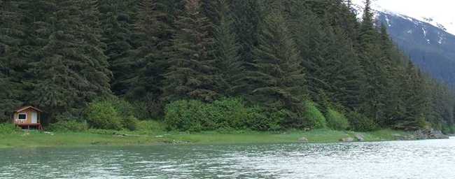
The land is in a beautiful old growth forest at the mouth of a valley,
bordered on one side by a pink salmon stream and fronted by a pleasant
beach. Unfortunately, the forest is very
wet, all the likely openings between the trees for potential cabins
harboring soggy ground or standing water.
Furthermore, my father divided the lot in two years ago and sold one to
a neighbor in town, so it was not particularly isolated.
I left hoping that the other property would suit me better.
In 2001, Larry and I sailed
down to Port Snettisham and toured my father's other property at
the entrance to Port Snettisham near Pt. Amner.
The land is in a beautiful old growth forest at the mouth of a valley,
bordered on one side by a pink salmon stream and fronted by a pleasant
beach. Unfortunately, the forest is very
wet, all the likely openings between the trees for potential cabins
harboring soggy ground or standing water.
Furthermore, my father divided the lot in two years ago and sold one to
a neighbor in town, so it was not particularly isolated.
I left hoping that the other property would suit me better.
The next summer my father and I flew down to the other
property for
a comparison, my future plans still vague in my mind.
Wandering around the land in late October, I was delighted to find site
after site of buildable land. The mature
old growth forest left wide open spaces among the trees, most with
views of the water. Following is an
excerpt of my journal entry recounting the trip:
12/4/02
Friday was foggy but the weekend
dawned
with a 300 foot ceiling and we made it. The emerald water was
glassy and reached almost to the trees on the tiny point of land that
protruded from the fjord wall. Several western grebes were there
when we landed, diving into flawless surface...Bald eagles sat at the
edge of the water and gazed down. The property turned out to be
much more than I'd expected or hoped. The sun glowed between the
trees on perfect, flat terraces of moss and ferns. I kept
shouting "Is this our land?" each time I saw an ideal building
site. The rocky point at the east corner is inspiring. Licheny,
above high tide, flat benches to gaze up and down the inlet and into
the perfect little cove above it. The creek shone over its little
waterfalls in the sunshine.
Thickets of currents grew at the forest edge. It also turned out to be much larger than
expected. After half an hour's exploration
I was utterly thrilled, convinced that it was worth doing anything to
bring people to see. I left the ancient
trees and we took off, flying up the Whiting, over Crescent
Lake and down the Speel
River side and over the ridge home. Half a dozen swans on both lakes...found a sea
lion rookery at the entrance on a rock like any other along the shore. Seals in the water.
At home I began seriously planning.
After some initial meetings with the City I discovered that I could do
little in the way of permitting for the next summer without a site plan. In November I hastily chartered a plane and
Larry, my friend Dan and I went down and surveyed the lot in order to
site cabins and take elevations. It was a
primitive job, but with the help of a compass, a 100' tape, and a lot
of estimation, I put together a reasonable plan.
Each cabin was designed to have a view of the water in a location where
no trees needed to be cut for construction.
The result was a rather haphazard, organic site plan which later became
a more accurate and formal grading
plan.